


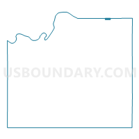
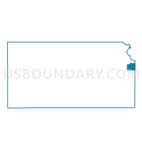
Merriam 1-01 Voting District, Johnson County, Kansas
About
Outline

Summary
| Unique Area Identifier | 585122 |
| Name | Merriam 1-01 Voting District |
| County | Johnson County |
| State | Kansas |
| Area (square miles) | 0.25 |
| Land Area (square miles) | 0.25 |
| Water Area (square miles) | 0.00 |
| % of Land Area | 100.00 |
| % of Water Area | 0.00 |
| Latitude of the Internal Point | 39.04221610 |
| Longtitude of the Internal Point | -94.69585580 |
Maps

Graphs
Select a template below for downloading or customizing gragh for Merriam 1-01 Voting District, Johnson County, Kansas


Neighbors
Neighoring Voting District (by Name) Neighboring Voting District on the Map
- Kansas City Ward 12 Precinct 05, Wyandotte County, KS
- Kansas City Ward 12 Precinct 07, Wyandotte County, KS
- Kansas City Ward 12 Precinct 08, Wyandotte County, KS
- Merriam 1-02 Voting District, Johnson County, KS
- Overland Park 1-01 Voting District, Johnson County, KS
- Shawnee 1-01 Voting District, Johnson County, KS
Top 10 Neighboring County Subdivision (by Population) Neighboring County Subdivision on the Map
- Overland Park city, Johnson County, KS (173,372)
- Kansas City city, Wyandotte County, KS (145,786)
- Shawnee city, Johnson County, KS (62,209)
- Merriam city, Johnson County, KS (11,003)
Top 10 Neighboring Place (by Population) Neighboring Place on the Map
- Overland Park city, KS (173,372)
- Kansas City city, KS (145,786)
- Shawnee city, KS (62,209)
- Merriam city, KS (11,003)
Top 10 Neighboring Unified School District (by Population) Neighboring Unified School District on the Map
- Shawnee Mission Public Schools Unified School District, KS (219,161)
- Turner Unified School District 202, KS (18,623)
Top 10 Neighboring State Legislative District Lower Chamber (by Population) Neighboring State Legislative District Lower Chamber on the Map
- State House District 18, KS (21,120)
- State House District 23, KS (20,831)
- State House District 24, KS (20,368)
- State House District 33, KS (20,337)
- State House District 31, KS (19,669)
Top 10 Neighboring State Legislative District Upper Chamber (by Population) Neighboring State Legislative District Upper Chamber on the Map
- State Senate District 10, KS (76,355)
- State Senate District 6, KS (66,722)
- State Senate District 7, KS (66,551)
Top 10 Neighboring 111th Congressional District (by Population) Neighboring 111th Congressional District on the Map
Top 10 Neighboring Census Tract (by Population) Neighboring Census Tract on the Map
- Census Tract 436, Wyandotte County, KS (6,580)
- Census Tract 522.01, Johnson County, KS (3,524)
- Census Tract 522.02, Johnson County, KS (3,290)